


London Tube Map
London Tube Map ၏ ရွင္းလင္းခ်က္
This application includes all London Tube/Underground lines, DLR, London Overground, TfL Rail and Trams. It combines an offline interactive map with a journey planner and a live status monitor.
Key features:
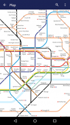
Offline Map: pan, pinch, search for stations and lines. Day Tube Map and Night Tube Maps are included.
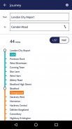
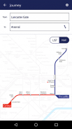
Offline Journey Planner: finds the fastest route to your destination using the specified service (day/night) and type of transport. Top London landmarks and touristic attractions are also included (London Eye, Big Ben, Tower of London etc).
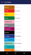
Line Status: checks the current status of the public transportation (requires Internet Connection).
Powered by TfL Open Data
ဤလျှောက်လွှာကိုအားလုံးလန်ဒန် Tube / မြေအောက်လိုင်းများ, DLR, လန်ဒန် Overground, TfL ရထားနှင့် Tram ပါဝင်သည်။ ဒါဟာခရီးစီမံခြင်းနှင့်တိုက်ရိုက် status ကိုမော်နီတာနဲ့အော့ဖ်လိုင်းအပြန်အလှန်မြေပုံပေါင်းစပ်။
အဓိကသော့ချက်များ:
အော့ဖ်လိုင်းမြေပုံ: ဒယ်အိုး, အဖြစ်တော့, ဘူတာနှင့်လိုင်းများအဘို့အရှာဖွေရေး။ နေ့ Tube Map နှင့် Maps ကိုထည့်သွင်းထားပါသည်ည Tube ။
အော့ဖ်လိုင်းခရီးအစီအစဉျ: သင်၏ပုသတ်မှတ်ထားတဲ့ဝန်ဆောင်မှု (နေ့ / ညဥ့်) ကို အသုံးပြု. destination သည်နှင့်သယ်ယူပို့ဆောင်ရေးအမျိုးအစားမှအမြန်ဆုံးလမ်းကြောင်းတွေ့။ ထိပ်တန်းလန်ဒန်အထင်ကရအဆောက်အနှင့်ခရီးသွားဧည့်ဆွဲဆောင်မှုလည်း (လန်ဒန်မျက်လုံး, Big Ben က, လန်ဒန်စသည်တို့ကို၏မျှော်စင်) ထည့်သွင်းထားပါသည်။
လိုင်းအခြေအနေ: အများပြည်သူသယ်ယူပို့ဆောင်ရေး (အင်တာနက်ကော်နက်ရှင်လိုအပ်ပါတယ်) ၏လက်ရှိအနေအထားကို check လုပ်ပေးပါတယ်။
TfL ပွင့်လင်းဖို့ဒေတာများက Powered
London Tube Map - APK သတင္းအခ်က္အလက္
APK ဗားရွင္း: 1.05package: maplabs.londonLondon Tube Map ၏ ေနာက္ဆုံးဗားရွင္း
အျခား ဗားရွင္းမ်ား


က႑တူအက္ပ္မ်ား


သင္ႏွစ္သက္ႏိုင္သည္မ်ားမွာ...


